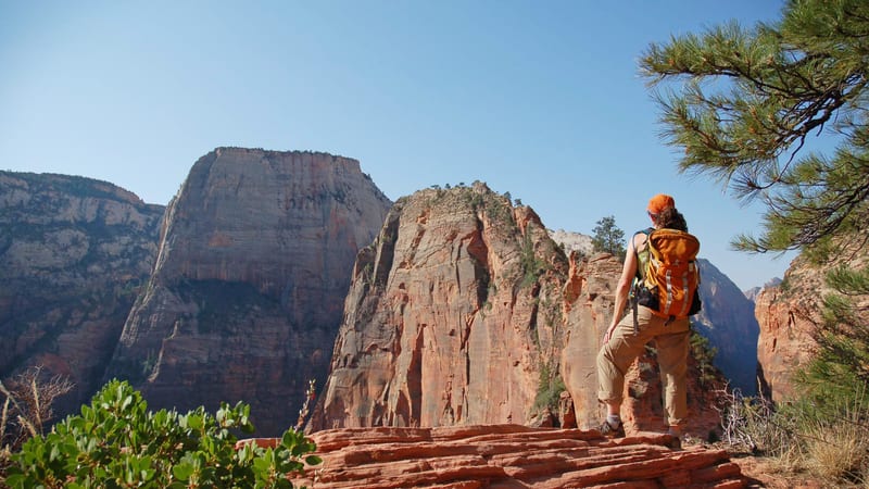
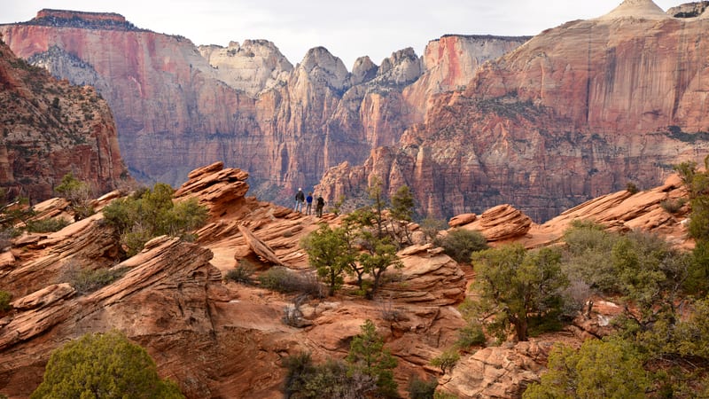
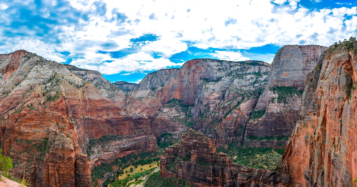
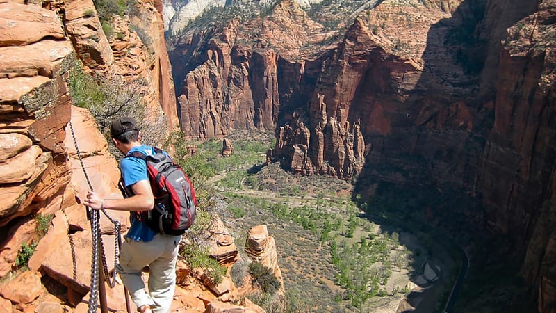
PARKS Atlas
A sweeping panorama of Zion Canyon in summer, with red sandstone cliffs rising on both sides above a forested canyon floor under a clear blue sky, looking along the approach to the Angels Landing trail.

Utah · National Park · Trails

Hiking in Zion

From chain-clutch ridgelines to waist-deep river canyons — every trail puts the wall right above your head.

Zion Canyon · Hiking in Zion National Park

Trails

Ten trails worth your time in Zion

Zion is a hiker's park. Most of the high points sit at the end of a trail — the shuttle drops you at the canyon floor and the routes climb from there. These ten trails cover the full spread: chain-clutch ridgelines, waist-deep river canyons, paved riverside walks, and the half-mile payoff hike east of the tunnel. Pick by time on foot, by who you're hiking with, and by whether you're holding a permit.

Aerial view of the Angels Landing switchback trail carved into red sandstone cliffs above Zion Canyon

Angels Landing

4.9 (39,598)

4.8 mi 1,745 ft gain 3–5 hr

Strenuous Out & back Permit required

The chain-clutch ridge walk to a 1,488-ft fin above Zion Canyon. Permit required since 2022 — apply via the seasonal or day-before lottery on Recreation.gov. Budget extra time for the technical sections and avoid when wet or icy.

A hiker looking out over a sweeping Zion Canyon vista from a layered sandstone overlook

Scout Lookout via West Rim Trail

4.9 (19,848)

3.8 mi 1,141 ft gain 2.5–3 hr

Hard Out & back

Same trailhead and switchbacks as Angels Landing but stops at Scout Lookout — no chains, no permit, and the same canyon overlook the chain section leads to. The smart play if the Angels Landing lottery didn't go your way.

A lone hiker wading the Virgin River between the towering sandstone walls of The Narrows in Zion

The Narrows (Bottom Up to Big Springs)

4.9 (6,144)

9.3 mi 872 ft gain 5–8 hr

Hard Out & back

Wade straight up the Virgin River where the canyon pinches to 20 feet wide. The bottom-up day hike from Temple of Sinawava needs no permit — turn around at Big Springs. Rent neoprene socks and a walking stick in Springdale.

The Virgin River flowing past smooth boulders deep within the red sandstone walls of The Narrows in Zion

The Narrows (Top Down)

4.8 (1,503)

16.8 mi 2,076 ft gain 8–10 hr

Strenuous Point to point Permit required

The full through-hike from Chamberlain's Ranch. Permit required — caps at 80 hikers per day. Arrange a shuttle from Springdale. Can be done as an overnight with reserved campsites. The deepest water and tallest walls are in the final 4.5 miles.

A paved riverside trail winding along the Zion Canyon floor beneath towering red sandstone cliffs

Floating Rock via Narrows Riverside Walk

4.9 (15,880)

6.4 mi 1,581 ft gain 3.5–4 hr

Moderate Out & back

A taste of the Narrows without the full commitment. Starts on the paved Riverside Walk, then continues into the river to Floating Rock. The water gets knee- to waist-deep — proper shoes are non-negotiable.

A sweeping aerial view of Zion Canyon with red sandstone cliffs flanking the Virgin River valley

Observation Point via East Mesa Trail

4.8 (9,485)

7.0 mi 705 ft gain 2.5–3 hr

Moderate Out & back

The big view down onto Angels Landing — taller, quieter, and now best approached from East Mesa Trailhead (4WD required) while the original Weeping Rock route remains closed. Sunrise is the move.

The view from Canyon Overlook across Zion Canyon, with red sandstone cliffs above a winding road

Canyon Overlook Trail

4.8 (15,730)

1.0 mi 216 ft gain 30 min

Moderate Out & back Kid friendly

The highest payoff-per-step trail in the park. Just east of the Mt. Carmel tunnel, 30 minutes to a railing perch over Pine Creek Canyon. No shuttle needed — drive to it. Sunrise and sunset are the moves.

A waterfall cascading down striated red sandstone canyon walls in Zion National Park

Emerald Pools Trail

4.6 (7,100)

3.0 mi 583 ft gain 1.5–2 hr

Moderate Loop Kid friendly

A tiered set of seep-fed pools and waterfalls below the Court of the Patriarchs. Lower pool is stroller-friendly on a paved path; upper pool is a steeper scramble but worth it after spring runoff. Watch your footing — more injuries here than any trail in the park.

The Virgin River winding through Zion Canyon below the Watchman peak under a blue sky

The Watchman Trail

4.7 (22,550)

3.3 mi 636 ft gain 1.5–2 hr

Moderate Out & back Kid friendly

Overlooked because it's right at the south entrance while everyone rushes to the shuttle. Steady switchbacks to a plateau overlooking Springdale, the Watchman tower, and Bridge Mountain. Best at sunset when the crowds have cleared.

Autumn cottonwood trees lining the Virgin River below the Watchman peak in Zion Canyon

Pa'rus Trail

4.5 (7,776)

3.3 mi 144 ft gain 1–1.5 hr

Easy Out & back Dog friendly Kid friendly

The only trail in Zion that allows dogs (leashed) and is fully paved, wheelchair-accessible, and stroller-friendly. A flat riverside walk with cottonwood shade and canyon vistas. The wind-down hike after a big day. Note: toxic algae in the river — keep dogs out of the water.

Trail data powered by AllTrails. Save offline maps, see live conditions, and download GPX tracks with AllTrails+.

Zion trail conditions alerts

One email when smoke, storm, or fire affects Zion trail access. Trail-specific — not the same as our lodging alerts.

Save on Entry

One pass covers Zion — and every other US national park.

The America the Beautiful annual pass pays for itself in two or three park visits. Free entry, free passenger fees, and no more fumbling for a credit card at the kiosk.

Buy your pass → Learn more about the pass

Ships from US Park Pass. Free shipping in the continental US.